
Professional Drone Training Tailored to Your Needs
Learn how to effectively map, analyze & share your drone data!

Drone training for the Department of Environment, Fisheries Division and ATC, Antigua and Barbuda.
Get your drone program off the ground today
Based on your needs, resources & skill level, I will teach your team everything you’ll need to know through classroom learning, hands-on flight skills and practical exercises to ensure success from the start!
The Drone Start Up Package + with a Needs Assessment and Proof of Concept
Avoid common pitfalls to new drone operations!
Obtain sound advice to get your drone program running from the start! In this package I will help you identify essential resources to quickly launch a safe and successful drone program for your team. I will first carry out a needs assessment to better understand your data requirements and determine the most suitable drone applications based on your organization’s capacity and workflows. During the course, your team will learn how to safely fly, plan, conduct and process a variety of drone surveys. Results will be used to develop ‘Proof of Concept’ use-cases specific for your organization’s needs. You will also learn the steps required to successfully undertake ‘commercial drone operations’ and be provided with a final needs assessment so you will know all of the various drone equipment and software you will need to successfully launch!
commerical mapping & Monitoring with Drones Package
Provide advanced skills for your team to conduct UAS operations professionally!
Your team will learn how to practically apply a commercial UAS Policy and Standard Operating Procedures to run a safe and successful professional drone program. Advanced mapping techniques and training in the development of a drone mapping monitoring strategy, from design to implementation will be covered. Learn all about advanced flight planning, methods for data collection, information creation, data management and spatial analysis tools as well as how to widely share information via web-based platforms.
Drones for Agriculture: Participatory Mapping & Spatial Analysis Training package
Build the knowledge and skills of your team over several months with this complete training package!
This comprehensive training package includes the planning and development of agricultural monitoring strategies. Your team will learn key aspects of conducting drone mapping and agricultural monitoring over the growing season. I’ll also introduce you to several web-based tools (such as DroneDeploy, Google Earth, ArcGIS Online) to help us easily plan and design a monitoring site using drone technologies. You will learn how to determine in-field data collection methods, undertake participatory mapping exercises, create spatial data and conduct web-based analysis to create useful information for your applications and audiences. Participants will be guided through a variety of practical exercises - both field and computer-based - in the creation of mapping information and sharing of results using a variety of reporting and web-mapping tools. These skills will not only support more informed decision-making, they will save you time and resources!
“Kim is an excellent teacher and her drone training course was so beneficial to the Mustique Company. She customised the course to suit our needs which included conservation, operations, maintenance and security. I highly recommend this versatile course. Kim will teach you tips and tricks you won’t learn elsewhere!”
Or the following courses Can be packaged for your Exact needs

INTRODUCTION TO safe DRONE FLYING
Acquire the basic skills to fly drones safely and legally
This is an opportunity to learn everything you need to know about drones, with both classroom training and hands-on flight practice! I will train you in drone hardware, accessories and software components, as well as national policy and regulations. Learn about flight safety and emergency procedures, plus standard operating procedures including site evaluations, flight conduct, site inspections and flight checks. Once you have completed this course, you will have all the knowledge and skills you need to capture great aerial photos and videos and, most importantly, to safely pilot a drone.
INtro to DRONE flying, Surveys and MAPPING
Learn how to conduct surveys and create orthomosaics and 3D models from your aerial drone data
I will provide you with the skills you’ll need to safely and effectively conduct drone mapping surveys. You will receive an overview of drones and payload sensors and practical experience using the most popular drone mapping and analysis software available today. I will cover topics including flight planning, site evaluations, flight checks and logs, as well as drone surveys, mapping and data collection techniques.
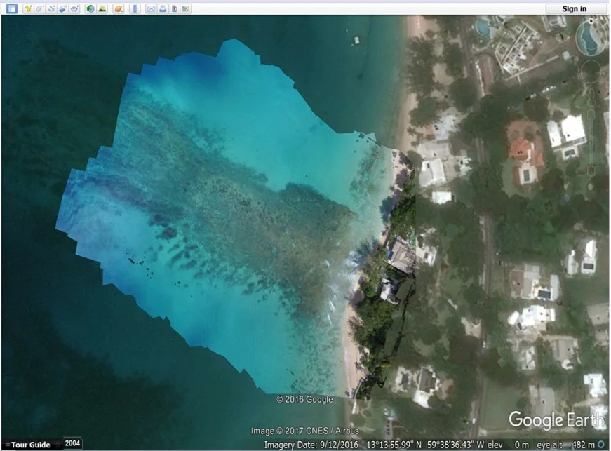
Drone Orthomosaic Results in Google Earth. Mullins Reef, Acropora Nursery Site, Barbados

Drone photography 101
Capture amazing aerial shots on every flight!
Learn the basics of your drone’s camera settings and how to take those ‘iconic’ drone shots. You will learn the practical skills you’ll need to capture high-quality images and videos with your drone. Need promo materials for your organization? I will also introduce you to easy-to-use and freely available photo and video editing software to get you started.
Developing a drone program
As drone technology continues to advance, it becomes more efficient and cost-effective than ever before. Despite the tremendous benefits, getting started can be confusing and complex! With so many choices of drones, sensors and software available it can be difficult to determine how best your organization can use this technology. I will help you identify the most effective solution that is aligned for your applications, skills and budget!

uas POLICY, operations manual & data management protocol
Acquiring a drone is exciting, but safe, lawful and efficient flight operation should always be the #1 priority. We will work together to develop a drone policy and operational procedures to cover all aspects of a drone mission. I will help your organization to determine what licensing you require, create a safety policy, manage flight requests, and develop flight checklists, maintenance procedures and data management protocols. I will then ensure that the subsequent training requirements of your team are all met.
Additional Drone Mapping Surveys & Monitoring Courses Available for:
Utilities & Inspections, Insurance, Disaster Management, Search & Rescue, Surveillance & Enforcement & Underwater Drones (ROVs)

Besides the purchase of your UAV, depending your intended application there are a number of useful drone accessories available.